 Click Image For The Sailboat Company's Home Page
Sailboat Navigation
Getting from one point to another in a small sailboat in coastal waters has never been a big deal. If you can see land everywhere, who needs to navigate with instruments. During your career as a sailor, your not going to navigate with instruments most of the time. If you travel up and down our east coast by boat, you still don't need to be an expert navigator. However, knowing how to use a compass, chart, sextant, GPS receiver and the latest electronic gadget can't hurt your chances at getting where your going safe and sound. If you charter sailboats or cruise with your own boat, you really need to know where you are, where you are going and your approximate arrival time. That means you need to be a navigator.
Most sailors buy a compass when they buy their boat. Some units come with lights and an angle of heel indicator built-in. In my opinion, the angle of heel indicator is the most useful part of the whole instrument. 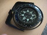 We all want to know what the heel angle is when the wind is up. The other two components, the lights and the compass get very little use. Every now and then when the fog doesn't lift or you have some other visibility problem, you really need a compass. Navigating with a compass at night or sailing at night should be avoided if possible. Coastal or lake sailing at night with night time visibility will increase the possibility of collision or accident. If you don't sail at night, you don't need lights in your compass. If your going to sail in an area where land is not visible part of the time, you need a compass as a primary means of navigation. The compass needs to be installed correctly and it's accuracy verified by checking it against a compass rose on a nautical chart. You need to practice with your compass whenever possible to maintain your skill level and also make sure it functions properly. Fluid lost can be a problem in most permanently mounted compasses. A compass with a knot meter installed next to it on the same bulkhead isn't worth much because of interference. A portable compass that moves around on the boat can also be a problem for the same reason. Metal objects located within 2 feet of a compass can cause substantial errors.
A sailor needs a nautical chart of his or her sailing area. If your sailing on a large inland lake, obtain the best map possible for your area. We do have fog and weather related storms on lakes. Your nautical chart will have latitude and longitude lines, major geographical features, buoys and water depths. 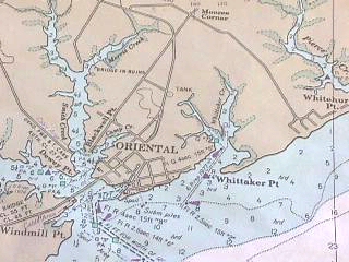 Everyone should know that latitude lines go around the earth in a horizontal direction and they are all 60 miles apart. One degree of latitude is worth 60 miles. We start measuring latitude at the equator with 0 degrees latitude and go north or south with greater numbers. Each latitude degree is divided into 60 minutes and every minute is divided into 60 seconds. We sometimes see minutes and seconds divided into 100 parts instead of 60 parts. Both systems work the same way. Longitude lines are north and south lines that go between the equator and the north and south poles. The distance between these lines become less as the lines go north or south from the equator. In North Carolina, we have a distance of 54 miles between longitude lines. At the equator, the distance is 60 miles. The way Columbus navigated to this country is with latitude lines. He maintained the same angle between his ship and the sun as he proceeded west. He sailed a latitude line west until he ran into the new world. A big problem with charts is that are hard to handle in the cockpit.
You don't need a sextant for coastal or lake navigation, but understanding how celestial navigation works wont hurt most sailors. You never can tell when the knowledge will come in handy. 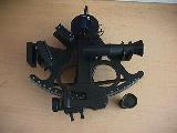 The sky at night is like one big road map that's moving over our head. The stars move by the same place on earth every 4 years. We can buy a reference book that tell use exactly where the stars are located at any given time. We can pick a visible planet or star at a specific time and determine the coordinates of the location on earth directly below the star. We measure the angle between the horizon and the star and we will know that our location on earth is somewhere on a circle below that star. We do the same thing again with a different star and where the two circles cross is our position. It hard to practice if you don't have a horizon and most coastal and lake sailors don't have a usable visible horizon. Sextant navigation errors are mostly procedures mistakes made by the user.
 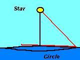 A lot of practice can get your accuracy down into the 1 to 3 mile range for a fix. Navigation with sun shots are pretty easy. Identifying the right star
can be very hard, but there are helper programs to help with star identification. The Davis Brand of plastic sextant is a quality product at a reasonable price.
A lot of practice can get your accuracy down into the 1 to 3 mile range for a fix. Navigation with sun shots are pretty easy. Identifying the right star
can be very hard, but there are helper programs to help with star identification. The Davis Brand of plastic sextant is a quality product at a reasonable price.
A GPS receiver can be a great backup for a compass and currently, a better knot meter than most knot meters. Coastal and lake sailors need a good knot meter to measure the results of their trim adjustments. Pull the jib sheet in 2 inches and the boat goes faster or slower? We are talking about little adjustments and little changes in boat speed. We need something that tell us whether our adjustments are good or bad. 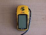 That's how we learn. Make sure your GPS receiver measures your speed down to one tenth of a knot. Most current GPS receivers can measure your trim differences. Permanently installed knot meters work well if they are analog units. Sailors can tell if the needle moves in the right or wrong direction. Most sailors have a hard time with digital knot meters. You have to remember the speed numbers between trim adjustments. A GPS receiver cost about $200 and that's a bargain price for a distance, direction and speed instrument.
Most electronic gadgets work well when new. If you don't use the equipment most of the time, you will forget how to operate the new toy between uses. If it's simple, waterproof and has a off/on switch, most of us can operate the equipment every time. Make sure lines don't wrap around units installed in the cockpit. The primary use of a sailboat's cockpit is for line handing and maybe a guest every now and then. An auto-pilot can be a great navigation tool for most coastal sailors. Here again, correct installation is very important.
Being able to use a computer is another important part of the learning process for sailors. Getting comfortable with your computer means that you can download applications that will print colored maps of your sailing area and give you distance and direction with mouse clicks. Our technology has come a long ways in the last ten years. All sailors need to know how files are copied and stored on computers and get familiar with the Internet. The Internet is a big resource for sailors and the best way we have to communicate with each other. If you own a color printer and a GPS, you can locate the buoys in your sailing area and add them to your charts. Then you can print your charts with your local buoys or anything else you want to add to your charts.
Understanding sailboat navigation is important for most sailors when the weather is not cooperating or when we need to navigate to that far off distant place. Becoming a good navigator is not necessarily our first sailing priority, but it's an important skill that all sailors should understand and practice whenever possible.
The Sailboat Company
Richlands, NC 910-324-4005